
ISSUED: 15/08/2024
FLYING UNDER VISUAL FLIGHT RULES (VFR)
01 - BEFORE THE FLIGHT
Before every flight, pilots have a legal obligation to ensure the safe conduct of the operation. It’s essential to establish a thorough pre-flight planning process, which should include verifying the validity of your personal license, assessing aircraft serviceability, and reviewing the latest weather and NOTAMs.
As the pilot in command, it is crucial to evaluate your own fitness to fly. This assessment encompasses both physical and mental well-being, as well as your proficiency and currency for the planned flight.
Prior to in-depth planning for a specific destination, conduct an initial review of the weather and NOTAMs to identify any immediate concerns, such as adverse weather conditions or training restrictions.
If your flight involves multiple aerodromes, make sure to check the NOTAMs and weather conditions for each location you intend to visit.
Lastly, conduct your flight planning in a quiet, distraction-free environment. If it has been some time since your last flight, allocate extra time to refresh your knowledge of necessary procedures and items that need to be checked.
Threat and Error Management (TEM)
Dento Aviation promotes a 'Threat and Error Management' (TEM) approach to flight planning and execution. TEM focuses on the timely identification of threats, errors, or undesired aircraft states, and involves implementing appropriate responses to ensure safe flight operations.
Threats may include unpredictable weather or complex airspace scenarios. It is essential to consider how to mitigate these risks. Additionally, potential errors during flight execution—such as incorrect aircraft configuration or navigation issues—should also be acknowledged. Employing a systematic approach throughout the various stages of the flight and utilizing checklists can significantly reduce the likelihood of errors.
Weather
Pilots must assess that cloud base and visibility conditions are suitable for the intended flight. Safe minimum visibility standards can vary based on factors like terrain and obstacle elevation.
Flying below 1,500 feet AGL is not recommended, as it can complicate visual navigation, decrease terrain clearance, and heighten the risk of encountering obstacles such as tall masts.
In addition to reviewing the weather at the departure and destination aerodromes, develop an understanding of the en-route weather conditions. Analyze TAFs and METARs for airports along your flight path, keeping in mind elevation differences when evaluating reported cloud levels.
Weather Constraints for Training Flights
Training flights will only proceed if weather conditions satisfy VFR minima as outlined in the AIP. No training flights will be conducted in significant weather conditions that pose a risk to flight safety. However, “basic instrument flight” training may occur under IFR conditions, provided both the Flight Instructor and the aircraft are appropriately certified.
All operations must remain within the operational limits of the training aircraft as stated in the pilot's operating handbook.
When establishing weather limits, it is vital to consider the experience level of each individual applicant. The following table serves as a guide:
NOTAMs
You must check NOTAMs before flight. Further details of temporary changes can be found in AIP supplements.
FUEL
Part-NCO specifies minimum fuel reserves above the amount required to fly the intended route:
- 10 minutes at maximum continuous cruise power at 1,500 ft above the destination under VFR by day, taking off and landing at the same aerodrome/landing site, and always remaining within sight of that aerodrome/landing site;
- 30 minutes at holding speed at 1,500 ft above the destination under VFR by day; and
- 45 minutes at holding speed at 1,500 ft above the destination or destination alternate aerodrome under VFR flights by night.
Aeroplane reserves are computed at ‘normal cruising altitude’ and for helicopters ‘best range speed’. These should be regarded as minimums for fuel carriage. It is important to know your anticipated fuel burn at different cruise power settings.
WEIGHT & BALANCE AND PERFORMANCE
It is a legal requirement for the aircraft to remain within its specified weight and balance envelope throughout the entire flight. Ensure that you are familiar with the methods for calculating weight and balance (W&B) for your specific aircraft, and accurately determine the weight of passengers and cargo on board.
Additionally, it is essential to verify your takeoff and landing performance to ensure safe operations.
ROUTE PLANNING
It is a legal requirement to carry suitable and current navigation charts. While electronic charts are acceptable, the ATO strongly recommends having a paper chart as a backup.
For VFR flights, pilots should make effective use of moving map devices that incorporate current aeronautical data and are integrated into all phases of flight planning and execution.
Additionally, it’s advisable to review and mark the planned route on a 1:500,000 or 1:250,000 scale VFR chart, which serves as both a backup and an additional information resource during your flight preparation.
When evaluating your route, identify potential airspace hazards, high terrain, and other obstacles. Take these factors into account during planning; for instance, if the forecasted cloud base is lower than expected, it may be wise to choose a route that’s further from high ground.
While there is no legal mandate for a formal ‘minimum safe’ altitude during VFR flight, it is prudent to establish personal altitude thresholds for the intended route that you will not descend below. Be sure to have alternative plans in place should weather conditions render the original route unsuitable.
Keep in mind that the ‘Maximum Elevation Figures’ (MEF) displayed on VFR charts represent the highest terrain or obstruction expected in a given area, but do not include a safety margin and should not be considered a minimum safe altitude.
Even when using a moving map display, it’s important to identify significant ground features and/or visual reference points (VRPs) along your route. These may be necessary for ATC coordination when transiting controlled airspace or approaching an aerodrome.
Aim to fly at the highest practical altitude, considering airspace restrictions and aircraft performance. You may also want to select randomized altitudes for your cruise, rather than consistently choosing round numbers.
PILOT'S LOG (PLOG)
Creating a Pilot's Log (PLOG), whether electronically or on paper, is highly recommended for each flight. A well-organized PLOG should include:
- Timings and headings for each flight leg
- Radio frequencies in use
- Planned altitudes
- Safety altitudes
- Fuel planning details
02 - STANDARDISE EUROPEAN RULES OF THE AIR (SERA) VISUAL METEOROLOGICAL CONDITIONS (VMC) MINIMA

VFR flight requires that you remain in ‘Visual Meteorological Conditions’ at all times. The assumption of VFR flight is that you have enough visibility to control the aircraft by visual references and avoid collisions with terrain and other aircraft.
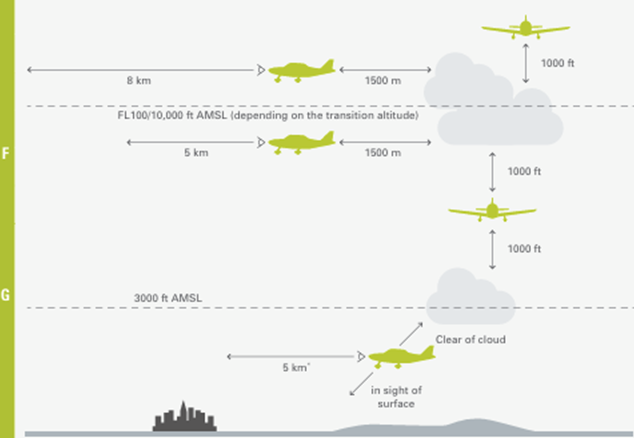
SERA.5001 VMC visibility and distance from cloud minima:
Table S5-1 (*) |
|||
Altitude band |
Airspace class |
Flight visibility |
Distance from cloud |
|
At and above 10,000 ft AMSL |
A (**) B C D E F G |
8 km |
1,500 m horizontally 1,000 ft vertically |
|
Below 10,000 ft AMSL and above 3,000 ft AMSL, or above 1,000 ft above terrain, whichever is the higher |
A (**) B C D E F G |
5 km |
1,500 m horizontally 1,000 ft vertically |
|
At and below 3,000 ft AMSL, or 1,000 ft above terrain, whichever is the higher |
A (**) B C D E |
5 km |
1500 m horizontally 1,000 ft vertically |
|
F G |
5 km (***) |
Clear of cloud and with the surface in sight |
|
(*) When the height of the transition altitude is lower than 10,000 ft AMSL, FL 100 shall be used in lieu of 10 000 ft.
(**) The VMC minima in Class A airspace are included for guidance to pilots and do not imply acceptance of VFR flights in Class A airspace.
(***) When so prescribed by the competent authority:
Flight visibilities reduced to not less than 1,500 m may be permitted for flights operating:
(1) at speeds of 140 kts IAS or less to give adequate opportunity to observe other traffic or any obstacles in time to avoid collision; or
(2) in circumstances in which the probability of encounters with other traffic would normally be low, e.g. in areas of low volume traffic and for aerial work at low levels.